Indonesia Map
Bali Map
The Island of Bali has an area of only 5,632 square kilometers ( 2,175 square miles ) and measures just 55 miles ( 90 kilometers ) along the north - south axis and less than about 90 miles ( 140 kilometers ) from East to West.
Because of this it's no problem to explore the island on day trip.
Located only two kilometers east of Java, Bali's climate, flora and fauna are quite similar to its much larger neighbour. The island is famous of its beautiful landcape. A chain of six volcanoes, between 1,350 meters and 3,014 meters high, streches from west to east. There are lush tropical forests, pristine crater lakes, fast flowing rivers and deep ravines, picturesque rice terraces, and fertile vegetable and fruit gardens. The beaches in the South consist of white sand, beaches of other parts of the island are covered with grey or black volcanic sand.
 |
| Mount Agung |
Rice Terraces
 |
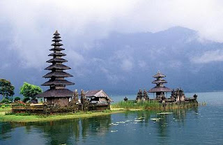
| Ulundanu Temple at Lake Bratan |
 |
| Ulundanu Temple at Lake Bratan |
 |
| Ulundanu Temple at Lake Bratan |
Ulundanu Temple at Lake Bratan
 |
| Ulundanu Temple at Lake Bratan |
 |
| Ulundanu Temple at Lake Bratan |
 |
| Ulundanu Temple at Lake Bratan |
Most people leave in the coastal areas in the South, and the island largest town and administrative center is fast growing Denpasar with a population now over 370,000. The villages between the town of Ubud and Denpasar, Kuta ( including Jimbaran, Tuban, and Legian, Seminyak, Basangkasa etc ), Sanur, and Nusa Dua are spreading rapidly in all direction, and before long the whole area from Ubud in the North to Sanur in the East, Berawa/Canggu in the West, and Nusa Dua in the South will be urbanized.
Sanur Beach
Tanah Lot Temple
 |
| Besakih Temple |
Besakih Temple
Besakih Temple at Sunrise
73's
91DA002 Andi


